


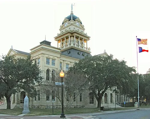
Bell County is a county in the U.S. state of Texas. It is in Central Texas and its county seat is Belton. As of the 2020 census, its population was 370,647. Bell County is part of the Killeen–Temple, Texas, Metropolitan Statistical Area. The county was founded in 1850 and is named for Peter Hansborough Bell, the third governor of Texas. In 2010, the center of population of Texas was located in Bell County, near the town of Holland.
Contents
History
In 1834–1835, Little River became part of Robertson's Colony, made up of settlers from Nashville, Tennessee, led by Sterling C. Robertson; they were the families of Captain Goldsby Childers, Robert Davison, John Fulcher, Moses Griffin, John Needham, Michael Reed and his son William Whitaker Reed, William Taylor, and Judge Orville T. Tyler. This area became known as the Tennessee Valley. Soon after (1836) the settlements were deserted during the Runaway Scrape, reoccupied, deserted again after the Elmwood Creek Blood Scrape, and reoccupied. Texas Ranger George Erath established a fort on Little River.
During 1843–44, settlers began returning. The next year, the Republic of Texas founded Baylor Female College (since developed as University of Mary Hardin–Baylor).
In 1850, Bell County was organized and named for Texas Governor Peter Hansborough Bell. The population then was 600 whites and 60 black slaves. Belton was designated as the county seat in 1851.
The last serious Indian raid in the area occurred in 1859. Bell County assumed its present boundaries with the 1860 resurvey of the line between Bell and Milam Counties.
In 1861, the county voted for secession from the Union. Residents were divided, as many yeomen farmers did not support the war. From 1862 to 1865, Union sympathizers and Confederate deserters holed up in "Camp Safety". Following the war, new social movements developed. In 1867, the Belton Women's Commonwealth, the first women's movement in Central Texas, was formed by Martha McWhirter. The group provided shelter to women in abusive relationships.
During the early years of the Reconstruction era (1865–1877), so much violence occurred in the county that the government stationed federal troops in Belton. Some racist whites attacked blacks and their white supporters. Corruption, lawlessness, and racial divides were severe. As in many areas, a local version of white paramilitary insurgents developed who were similar to the Ku Klux Klan; they worked to suppress black and Republican voting.
The coming of railroads in the late 19th century stimulated growth across the state. In 1881, the Gulf, Colorado and Santa Fe Railway, the first railroad to be built in Bell County, established Temple as its headquarters. Reflecting growth in the county, in 1884, the Bell County Courthouse was built. It is still used. The ambitious Renaissance Revival design was by architect Jasper N. Preston and Sons. As another improvement, in 1905, the Belton and Temple Interurban electric railway was completed, providing service between the cities.
Geography
According to the U.S. Census Bureau, the county has a total area of 1,088 square miles (2,820 km2), of which 1,051 square miles (2,720 km2) are land and 37 square miles (96 km2) (3.4%) are covered by water.
Adjacent counties
McLennan County (north)
Falls County (northeast)
Milam County (southeast)
Williamson County (south)
Burnet County (southwest)
Lampasas County (west)
Coryell County (northwest)
Demographics
2020 census
As of the 2020 census, the county had a population of 370,647. The median age was 32.7 years; 26.6% of residents were under the age of 18 and 11.9% of residents were 65 years of age or older. For every 100 females there were 95.2 males, and for every 100 females age 18 and over there were 92.5 males age 18 and over.
The racial makeup of the county was 48.7% White, 23.0% Black or African American, 0.9% American Indian and Alaska Native, 3.1% Asian, 1.0% Native Hawaiian and Pacific Islander, 8.9% from some other race, and 14.4% from two or more races. Hispanic or Latino residents of any race comprised 25.2% of the population.
86.3% of residents lived in urban areas, while 13.7% lived in rural areas.
There were 135,673 households in the county, of which 37.2% had children under the age of 18 living in them. Of all households, 48.5% were married-couple households, 17.6% were households with a male householder and no spouse or partner present, and 27.8% were households with a female householder and no spouse or partner present. About 24.8% of all households were made up of individuals and 7.7% had someone living alone who was 65 years of age or older.
There were 147,599 housing units, of which 8.1% were vacant. Among occupied housing units, 55.2% were owner-occupied and 44.8% were renter-occupied. The homeowner vacancy rate was 2.1% and the rental vacancy rate was 9.0%.
2010 census
As of the 2010 census, 310,235 people, 114,035 households, and 80,449 families resided in the county. The population density was 295.2 people per square mile (114.0 people/km2). The 125,470 housing units averaged 88 units per square mile (34/km2). The racial makeup of the county was 61.4% White, 21.5% Black, 0.8% Native American, 2.8% Asian, 0.8% Pacific Islander, and 5.0% from two or more races. About 21.6% of the population was Hispanic or Latino of any race; 14.9% were of Mexican, 3.6% were of Puerto Rican, 0.2% Cuban, and 0.2% were of Dominican descent.
As of the 2010 census, about 3.6 same-sex couples per 1,000 households were in the county.
2000 census
As of the 2000 census, there were 85,507 households, of which 40.10% had children under the age of 18 living with them, 56.60% were married couples living together, 12.30% had a female householder with no husband present, and 27.50% were not families. About 22.30% of all households were made up of individuals, and 6.50% had someone living alone who was 65 years of age or older. The average household size was 2.68 and the average family size was 3.14.
The population was distributed as 28.90% under the age of 18, 13.40% from 18 to 24, 31.90% from 25 to 44, 17.00% from 45 to 64, and 8.80% who were 65 years of age or older. The median age was 29 years. For every 100 females, there were 100.80 males. For every 100 females age 18 and over, there were 99.30 males.
The median income for a household in the county was $36,872, and for a family was $41,455. Males had a median income of $28,031 versus $22,364 for females. The per capita income for the county was $17,219. About 9.70% of families and 12.10% of the population were below the poverty line, including 16.30% of those under age 18 and 9.80% of those age 65 or over.
Education
Bell County is served by several school districts:
Areas in the boundary of Central Texas College's service area, as defined by the Texas Education Code, include all of Killeen ISD, Fort Hood and North Fort Hood, and the Bell County portions of Copperas Cove ISD and Lampasas ISD.
Areas in the boundary of Temple Junior College's service area include Academy ISD, Bartlett ISD, Belton ISD, Holland ISD, Rogers ISD, Salado ISD, Temple ISD, and Troy ISD.
State legislation does not specify the community colleges of the Bruceville-Eddy ISD and Moody ISD areas.
Transportation
Major highways
These major highways run through Bell County:
Interstate 14
Interstate 35
U.S. Highway 190
State Highway 36
State Highway 53
State Highway 95
State Highway 195
State Highway 201
State Highway 320
Loop 121
Loop 363
Spur 290
Mass transit
The Hill Country Transit District operates a regularly scheduled fixed-route bus service within the urban areas of Killeen and Temple, as well as a paratransit service throughout the county. Amtrak also has scheduled service to Temple.
Communities
Village
Salado
Census-designated place
Fort Hood (partly in Coryell County)
Pendleton
Ghost towns
Bland
Brookhaven
Donahoe
Ocker
Old Troy
Stringtown
Sparta
Tennessee Valley
Old Aiken
Pendletonville
Government and politics
Politically, Bell County tends to support Republican Party candidates for office. It has voted for the Republican presidential nominee every cycle beginning with Ronald Reagan in 1980. While the county had been trending Democratic, it rebounded in 2024 to give Republicans their strongest performance in 20 years. This is partially attributed to the large military presence, which tends to lean Republican, as well as the growth of Hispanics in the county, a population that shifted heavily towards Republicans in 2024.
The county is a bellwether for Texas, voting for the statewide winner of every presidential election in Texas, except in 1952 and 1956. In 1952 and 1956, Republican Dwight D. Eisenhower (who was born in Texas) won the state while losing Bell County.
Democratic strength in the county is concentrated in the city of Killeen, which gave Joe Biden 63.4% of the vote in the 2020 election. The remainder of the county, particularly the cities of Belton and Temple, is much more strongly Republican.